Log in
All resources
Create a design
Tools
21,768 Free Images of Title Page
maps from the earth and its inhabitants, vol. iv
maps from the earth and its inhabitants, vol. vii
maps from the earth and its inhabitants, vol. xiii
maps from the earth and its inhabitants, vol. xvi
maps from the earth and its inhabitants, vol. x
maps from the earth and its inhabitants, vol. vi
die reptilien und amphibien mitteleuropas (1912)
dr. wilh. junker's reisen in afrika 1875-1886
charles eugène perron
maps from the earth and its inhabitants, vol. v
maps from the earth and its inhabitants, vol. vi
charles eugène perron
maps from the earth and its inhabitants, vol. xv
flora of alaska
maps from the earth and its inhabitants, vol. xviii
south america in the 19th century
the art of the netherland galleries (1908)
hague school
maps from the earth and its inhabitants, vol. xiii
maps of journeys
le désert et le monde sauvage
fauna bl - mammalia
maps from the earth and its inhabitants, vol. v
denmark in the 19th century
maps from the earth and its inhabitants, vol. iv
1870s maps of scotland
frank leslie's illustrated newspaper, 1861
american civil war in 1861
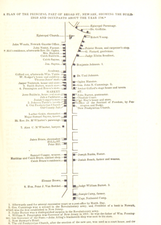
historical collections of the state of new jersey (1852)
stony brook, new jersey
orientalist painting
old maps of dakar
maps from the earth and its inhabitants, vol. xiii
old maps of luanda
maps from the earth and its inhabitants, vol. xvi
maps of central america
die reptilien und amphibien mitteleuropas (1912)
hierophis gemonensis
maps from the earth and its inhabitants, vol. iv
romney marsh
maps from the earth and its inhabitants, vol. xvi
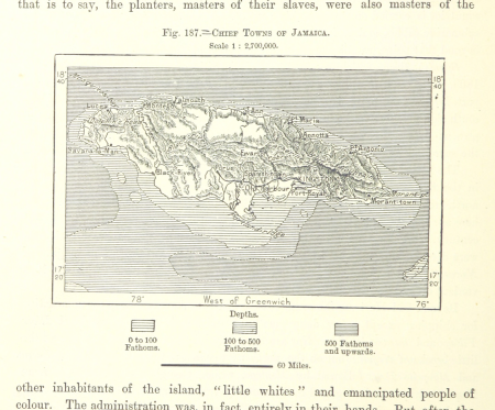
19th-century maps of jamaica
maps from the earth and its inhabitants, vol. ii
st malo
maps of the districts of the canton of bern
biel/bienne (administrative district)
maps from the earth and its inhabitants, vol. xvi
maps of the mexican war of independence
the uncivilized races of men in all countries of the world (1878)
africans in 19th-century art
maps from the earth and its inhabitants, vol. iv
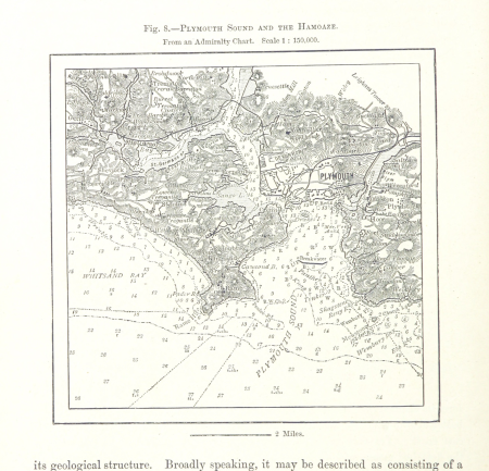
charts of plymouth sound
historical collections of the state of new jersey (1852)
maps of newark, new jersey
maps from the earth and its inhabitants, vol. vi
topographic maps of asia
dr. wilh. junker's reisen in afrika 1875-1886
friedrich rheinfelder
maps from the earth and its inhabitants, vol. v
1870s maps of finland
frank leslie's illustrated newspaper, 1864
charles e. h. bonwill
bakhchisaray palace in art
orientalism
portrait prints of men
joseph e. johnston
posters of maison de victor hugo
fortuné-louis méaulle
dirk iii of holland in engravings
mannerism
'iconographie' by anthony van dyck (petit palais)
baroque painting
frank leslie's illustrated newspaper, 1876
prints in the missouri history museum
three wonderlands of the american west (1912)
hudson river school
the comprehensive history of england (1876)
english-language maps showing history
maps from the earth and its inhabitants, vol. xvii
topographic maps of new york (state)
dr. wilh. junker's reisen in afrika 1875-1886
friedrich rheinfelder
from edinburgh to the antarctic. an artist's notes and sketches during the dundee antarctic expedition of 1892-93
port stanley, ontario
maps from the earth and its inhabitants, vol. xi
maps indicating exploration
maps from the earth and its inhabitants, vol. vii
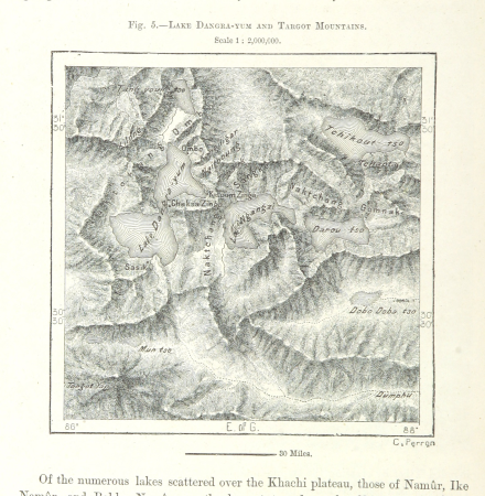
targot mountains
the art of the louvre (1905)
high renaissance
maps of rivers of south sudan
sobat river
maps from the earth and its inhabitants, vol. iv
maps of balmoral castle
maps from the earth and its inhabitants, vol. xiii
mount kenya
maps from the earth and its inhabitants, vol. iv
old maps of the isle of arran
maps from the earth and its inhabitants, vol. xvi
surveying in mexico
maps from the earth and its inhabitants, vol. vii
1870s maps of japan
maps from the earth and its inhabitants, vol. xvii
french louisiana
dr. wilh. junker's reisen in afrika 1875-1886
friedrich rheinfelder
maps from the earth and its inhabitants, vol. x
lake tana
maps from the earth and its inhabitants, vol. ix
adana
maps from the earth and its inhabitants, vol. x
khedivate of egypt
maps from the earth and its inhabitants, vol. vii
1870s maps of china
maps from the earth and its inhabitants, vol. iii
1870s maps of switzerland
maps from the earth and its inhabitants, vol. viii
temperature maps
portraits from the british library mechanical curator collection
gerard lake, 1st viscount lake
maps from the earth and its inhabitants, vol. v
maps of the north atlantic
die reptilien und amphibien mitteleuropas (1912)
zamenis longissimus
maps from the earth and its inhabitants, vol. iv
old maps of the firth of forth
maps from the earth and its inhabitants, vol. vi
pyatigorsk
maps from the earth and its inhabitants, vol. iv
maps of snowdonia
fauna bl - insecta
goliathus
sciurus vulgaris (illustrations)
le désert et le monde sauvage
maps from the earth and its inhabitants, vol. iv
1870s maps of london
maps from the earth and its inhabitants, vol. iv
sewers in london
maps from the earth and its inhabitants, vol. viii
ghats
maps from the earth and its inhabitants, vol. xiv
1870s maps of indonesia
maps from the earth and its inhabitants, vol. iv
old maps of swansea
maps from the earth and its inhabitants, vol. vii
charles eugène perron
maps from the earth and its inhabitants, vol. x
john hanning speke
maps from the earth and its inhabitants, vol. iv
old maps of leeds
maps of ardabil province
maps of sabalan
maps from the earth and its inhabitants, vol. xiii
1870s maps of africa
maps from the earth and its inhabitants, vol. iv
lowestoft
maps from the earth and its inhabitants, vol. iv
old maps of leeds
maps from the earth and its inhabitants, vol. iv
1870s maps of scotland
maps from the earth and its inhabitants, vol. vii
yarlung tsangpo
maps from the earth and its inhabitants, vol. iv
19th-century maps of the english channel
brehms tierleben. allgemeine kunde des tierreichs (1911)
notamacropus irma
maps from the earth and its inhabitants, vol. xi
1870s maps of algeria
maps from the earth and its inhabitants, vol. xvi
maps of the history of mexico
maps from the earth and its inhabitants, vol. iv
old maps of hastings, england
19th-century maps of sierra leone
maps of rivers of sierra leone
maps from the earth and its inhabitants, vol. vii
19th-century maps of korea
maps from the earth and its inhabitants, vol. xv
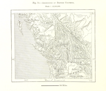
first nations people of british columbia
maps from the earth and its inhabitants, vol. viii
british india
maps of natal colony
maps of zululand
maps from the earth and its inhabitants, vol. iv
milford haven
maps from the earth and its inhabitants, vol. iv
rhins of galloway
maps from the earth and its inhabitants, vol. iv
1870s maps of wales
die reptilien und amphibien mitteleuropas (1912)
bufo bufo
maps from the earth and its inhabitants, vol. xiv
old maps of sydney
maps from the earth and its inhabitants, vol. xvii
old maps of washington, d.c.
maps from the earth and its inhabitants, vol. iv
linguistic maps of ireland
maps from the earth and its inhabitants, vol. vi
population density maps of europe
maps from the earth and its inhabitants, vol. iv
1870s maps of london
maps from the earth and its inhabitants, vol. iv
peterborough
die reptilien und amphibien mitteleuropas (1912)
vipera ammodytes illustrations
maps from the earth and its inhabitants, vol. x
rosetta (egypt)
rivers of the western cape
maps of the western cape
maps from the earth and its inhabitants, vol. vii
qinghai lake
11501 - 11600 of 21,768
Next page
/ 218